
2016
St. John's, Newfoundland, Canada
A Guide to Newfoundland Settlement and St. John's
Part 1: Legacy of the Fishery
Part 2: The Garrison Town and aftermath of the Great Fire of 1892 [1630-1905]
Part 3: Guide to the Built Heritage of St. John’s
I should like to acknowledge the Newfoundland and Labrador Heritage Web Site (Rev. March 2007) as a valuable resource. A fuller citation is given at the end of Part 1.
Part 1: Legacy of the Fishery
Part 1 examines early settlement and the migratory fishery. It could also serve as background for visitors who may plan to tour the Avalon Peninsula.
The migrartory fishery
From the early 16th century fishing ships sailed from France, Spain and Portugal to Newfoundland in the early spring and returned home with salted codfish. The island, including southern Labrador where Spanish Basques caught whales, was considered to be a fishing station, an extension of Europe. This annual return trip was called a migratory fishery as the fishers did not overwinter on the island.
Fishing by the Spanish Basques, Spain and Portugal was greatly dimished by the late 16th century as a result of Spain's loss of ships because of the defeat of the Spanish Armada. However, by then, England entered the fishery. Buy the 17th century the Newfoundland fishery came to be divided between France and England.
For many years, France sent more ships overseas than other nations, harvested more fish, and maintained a near monopoly of Newfoundland's south, west, and northeast coasts.
After about 150 years as the migratory fishery settlement started. Most of the French who settled lived at the French colony of Plaisance (Placentia) on the Avalon Peninsula's southwest coast, although the island's north and south coasts were also fished. Plaisance was established in 1660 and was sponsored as a strategic and military project rather than predominately a commercial fishing enterprise. [Refer to the illustration; Placentia is shown as a black dot on the east side of Placentia Bay]. The inhabitants fished and traded, and soldiers and administrators frequently acted as merchants as well. This colony remained under French control for about 50 years.

Illustration showing the Irish Loop [green] and the bays of the southern shore of the Avalon Peninsula. From: http://www.rosedalemanor.ca
In 1713, the Treaty of Utrecht forced the French to abandon their Placentia Bay settlements and the French migrated to Louisburg. Placentia became a British possession and, for a time, it equaled St. John's in size and importance, as evidenced by the future King William IV's summering at Placentia in, 1786, and using it as his base of operations when acting as surrogate judge in Newfoundland. By the 19th century, it was more fully eclipsed by St. John's and Harbour Grace. “From Wikipedia, the free encyclopedia”

French Shore illustration source: http://www.iat-sia.org
By the Treaty of Utrecht [1713] the French could still fish in season on the Newfoundland coast between Cape Bonavista and Point Riche [1].
In the Treaty of Versailles (1783) between Britain and France, the boundaries of the Treaty Shore were changed to Cape St. John and Cape Ray [1]. This was in effect until 1904.
The 1904 Anglo-French Convention, part of the "entente cordiale", provided that France would renounce its rights in Newfoundland under the Treaty of Utrecht, though French nationals could continue to fish - but not use the shore - within the traditional limits.” [1]
[1] from © 2001, J.K. Hiller French Presence in Newfoundland Bibliography
History buffs may be interested in visiting Castle Hill Historic Site in Placentia. It is about a one and one-half hour trip from St. John’s.
The English Fishery
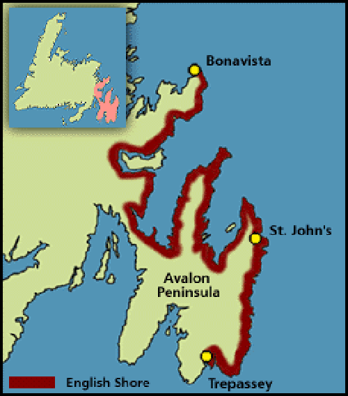
The English Shore during the 17th Century
Illustration by Duleepa Wijayawardhana, ©1998 Newfoundland and Labrador Heritage Web Site.
Along most of the English Shore, from Bonavista to Trepassey, settlement was under the direction England’s West Country migratory fishery. Earlier settlement was discouraged, but in the late 1670s the Committee for Trade and Plantations in London finally decided that settlement should be accepted. The English settlement of Newfoundland was justified, in part, as a way to protect the British fishery.

The Baccalieu Trail is about 230 km long
http://www.beyondbaccalieu.com
Note: In the English settlement of Newfoundland a colony or new settlement was described as a plantation. Plantation owners were called planters.
In 1610 John Guy and his backers brought settlers and established a plantation in what was then known as Cuper's Cove [Cupids]. Please refer to the illustration of The Baccalieu Trail. It was the second English colony in North America after Jamestown, Virginia, founded in 1607.
Around 1621 most of the original settlers had abandoned the plantation site, and its exact location was lost for more than 250 years. However, the present community of Cupids occupies this location and is a town with a population of about 750 people.Today you can visit the site and the Cupids Legacy Centre.
Around 1616, the Bristol Company of Merchant Venturers decided to branch out from the Cupids colony and establish a colony that they called ‘Bristol’s Hope’. Now known as Harbour Grace, this community was successful in the fishery and the town continued to grow to 11,458 residents by 1921. Current population is about 3000.
Another important fishing centre was Old Perlican that was settled by at least 1640. Old Perlican suffered at the hands of the French, being captured and burned in 1697, and again in 1705. Later in the same year there was another attack and the settlement was completely razed to the ground. Despite these attacks, and more sporadic French invasions in the following few years, Old Perlican remained resiliant and currently has a population of about 675.
Trinity, Trinity Bay was established by a fishing family from Old Perlican. This will be discussed in another Part.
The town of Cupids is within an hour’s drive of St. John’s. Cupids, Harbour Grace and Old Perlican are on the The Baccalieu Trail.
By 1621, early English settlements included Bristol's Hope [Harbour Grace], St. John's and the newly-founded Colony of Avalon at Ferryland [refer back to illustration of The Irish Loop]. Visitors to the Irish Loop, a convenient day’s drive from St. John’s, might consider a visit to Ferryland. In 1620 George Calvert, Lord Baltimore of England, established a settlement here. He wanted a colony in America where Catholics and Protestants could prosper together. Rather than stay in Newfoundland, Lord Baltimore obtained another land grant in the Chesapeake, now known as Maryland, [think Baltimore Maryland] and departed Newfoundland in 1629 with his family. The 30 or so fisher folk he left behind included men, women and children and they were among the very earliest permanent English settlers in Newfoundland. The community survived and eventually flourished as a permanent settlement.
The Colony of Avalon is an active archaeological site here that is worth a visit by history buffs
For nature lovers the site of the Mistaken Point Ecological Reserve is located on a headland of the southern Avalon Peninsula. It contains one of the most diverse and well-preserved collections of Precambrian fossils known. However, it does take an effort to get there and would be more suited to younger travelers or the devoted.
The Cape St. Mary's Ecological Reserve is both popular and an accessible place to see nesting seabirds.
The Witless Bay Ecological Reserve is a marine reserve and includes four seabird islands. The islands lie just a few km off the east coast of Newfoundland's Avalon Peninsula, between the communities of Bay Bulls and Bauline East, half an hour south of St. John's. The reserve area takes in 31 square km. Of this, 29 square km is a marine area around the islands.
During summer, boat tour operators will take you on the water. It is relatively sheltered and great for whale watching and sea-birds. Operators have pick-up and delivery services from the hotel.
Trinity is also great for whales and birds. Save this aspect for Trinity if you are going to Trinity.
Acknowledgements
The Newfoundland and Labrador Heritage Website was officially launched on November 25, 1997 as a joint project of the Memorial University's Smallwood Centre for Newfoundland Studies and the C.R. Bronfman Foundation of Montreal. It is a non-commercial, public history project that aims to provide a wide range of authoritative information on the province's history, culture, and geography. It is based at the Memorial University of Newfoundland. Faculty, graduate students, and professional writers contribute articles, while undergraduate students provide support as research assistants.
Newfoundland and Labrador Heritage Web Site (Rev. March 2007)
Part 2: An Insider’s Guide to St. John’s NL
The Garrison Town: Aftermath of the Great Fire of 1892 [1630-1905]
When I arrived in St. John’s, in1975, it was in vogue to refer to St. John’s as North America’s oldest city and vestiges of this sentiment remain to-day. I believe that it would be fair to say that St. John’s is among North America’s oldest settlements. As such, it is worth appreciating it for what it really is. Because Newfoundland and Labrador’s economy is largely resource and geographic-location based it has weathered both economic peaks and troughs over a 500 year period.
Year-round settlement began sometime after 1630 [1]. Although the population grew slowly in the 17th century, by 1675, St. John's was the largest settlement in Newfoundland. The population would increase in the summers with the arrival of migratory fishermen and decrease when they returned to their home ports. In 1680 fishing ships (mostly from South Devon) set up fishing rooms at St. John's. Also, they brought hundreds of Irish men to operate inshore fishing boats.

Fig 1 The salt-cod fishery was a mainstay of Newfoundland and Labrador’s economy throughout the 1800s. This picture shows salt cod drying on wharves or flakes.
The town's first significant defenses were likely erected because of commercial interests, following the temporary seizure of St. John's by the Dutch in 1665 [2]. A second Dutch attack in 1673 was unsuccessful.
The French admiral Pierre Le Moyne d’Urberville captured and destroyed the town in the Avalon Peninsula Campaign (1696). When 1500 English reinforcements arrived in late 1697 they found only rubble where the town and fortifications had stood.
Fort William was built in 1698 to protect English interests in Newfoundland, primarily against French attacks. It was the original headquarters of the British garrison in Newfoundland. The site of Fort William is now occupied by the Sheraton Hotel.
The French attacked St. John's again in 1705 (Siege of St. John's), and captured it for a period of time in 1708 (Battle of St. John's). It was regained by the English.
The Harbour remained fortified through most of the 18th and 19th centuries. The final battle of the Seven Years' War in North America (the French and Indian War) was fought in 1762, in St. John's. Following a surprise capture of the town by the French early in the year, the British responded, and, at the Battle of Signal Hill, the French surrendered St. John's to British forces under the command of Colonel William Amherst.
Fort William was poorly situated and was not able to effectively protect the Harbour or the settlement at St. John’s. Because of its location, it was vulnerable to land attack.
Finally, in 1779, the British deemed Fort William to be too susceptible to attack and built Fort Townshend on the high ground further to the west. The Rooms [Archives, Museum and Art Gallery] now stand on this site as does the headquarters of The Royal Newfoundland Constabulary.
In 1881 Fort William was demolished and its site cleared to accommodate the Canadian Pacific Railway hotel and rail yard. To-day the Sheraton Hotel stands approximately on this site. Fort William had a lifespan of 183 years.
Fort Townshend stood for more than 90 years [1779 until 1871] and it was the headquarters of the Newfoundland garrison during this time.

Fig 2 Map of St. John’s Harbour showing locations of Fort William [smaller fort D] and Fort Townshend [larger fort A]

Fig 3 Location of Fort Townshend

I
Fig 4 The Newfoundland Hotel 1920’s
The hotel was built on the site of Fort William. Note the rail tracks that led to the railway station up until about 1910. The Sheraton Hotel now stands on this site.
The core of the city was destroyed by fire several times, the most recent was the Great Fire of 1892 [3].

I
Fig 5 View of St. John's from Duckworth Street east following the Great Fire of 1892
The main street that you see going east to west is Duckworth Street. The street by the waterfront was known as the Lower Path. It is now Water Street.

Fig 6 In old St. John’s the wharves jutted into the harbour and were owned by the merchants
Water Street was the closest Street to the harbour. Now a single wharf is horizontal to the shore and located on Harbour Drive. Harbour Drive, which is now the waterfront street, was built by partially infilling the harbour.
The fire of 1862 destroyed more than two-thirds of St. John’s and 11,000 people were homeless after the fire. Three people died.
The first foreign country to send aid was Canada in the form of a large cargo of tents, food, and other provisions. In the coming days and weeks Canada shipped more supplies and also donated $20,000. Other countries also made significant donations.
Rebuilding was largely complete by 1895. The city generally retained its land use patterns, with commercial buildings concentrated around the harbour and residential areas climbing the hill. You can see this same pattern, in the downtown core, to-day.
The economy depended on the harbour and most people worked in offices, warehouses, factories, and wharves located near the water. People lived within walking distances of their workplaces, and within reach of shops and services. Residential housing reached as far north as Military Road although some larger merchants' homes were built, around 1905, as far north as Circular Road. The city consisted of narrow streets, row houses, and attached businesses, most of the latter concentrated on Water and Duckworth streets. The surrounding land, today comprising most of the city's area, was farmland, with summer homes and large private estates. This pattern remained relatively stable up until the end of WW II.
Much of the architecture in the downtown core dates from the immediate post-fire period. This will be discussed in a later Part.

Fig 7 Northern Valley, ca. 1942
The valley north of Circular Road and Empire Avenue was mostly undeveloped at the start of the Second World War. Empire Avenue was originally the rail route for the Newfoundland Railway.

Fig 8 Location of 24 Circular Rd. relative to the Sheraton Hotel
Walking distance to 24 Circular Rd., from the Sheraton, is about 10 min. Go north on Kingsbridge road, turn left at the Empire Ave. traffic light and proceed along Circular Rd. to no. 24. [source; Google maps]
References to picture sources
Fig 1 Salt Cod Drying, St. John’s, pre-1892 http://www.heritage.nf.ca/
Photographer unknown. Reproduced by permission of Archives and Special Collections (Coll. 137 03.02.003), Queen Elizabeth II Library, Memorial University of Newfoundland, St. John’s, NL.
Fig 2: Archives and Special Collections, QEII Library (Coll. 193.12.04.070), Memorial University of Newfoundland, St. John's
Fig 3 Photograph of St. John’s information plaque
Fig 4 http://www.heritage.nf.ca/
Photographer unknown. Reproduced by permission of Archives and Special Collections Division (Coll. 137 02_05_001), Queen Elizabeth II Library, Memorial University, St. John's, NL.
Fig 5 http://www.heritage.nf.ca/ From: Article by Jenny Higgins. ©2007, Newfoundland and Labrador Heritage Web Site
Photographer unknown. Reproduced by permission of Archives and Special Collections (Coll. 137 05.01.005), Queen Elizabeth II Library, Memorial University of Newfoundland, St. John's, NL.
Fig 6 Detail from Plan of the City of St. John's, compiled by W.R. Ryan (Halifax, NS: McAlpine Publishing Co., 1909). Adapted by Tanya Saunders www.mun.ca/mha/job/index.php#stjohns
Fig 7 Original picture courtesy of Library and Archives Canada, Archival Reference No. R112. MIKAN no. 4164986: Modified by J. Gow 2015: Source: Article by Keith Collier. ©2011, Newfoundland and Labrador Heritage Web Site
Citations
[1] Wikipedia, the free encyclopedia
[2] Article by Keith Collier. Copyright 2011. Newfoundland and Labrador Heritage Web Site.
[3] Article by Jenny Higgins. Copyright 2007, Newfoundland and Labrador Heritage Web Site.
Part 3: An Insider’s Guide to the Built Heritage of St. John’s
Architecture before the fire of 1892
Most, if not all, of the buildings described here are within reasonable walking distance of the Sheraton Hotel.
Some notable buildings escaped the fire of 1892.
Possibly the oldest surviving building in St. John's is Anderson House (Signal Hill). Built in 1802-1804, it is a wooden hipped-roof house, with a central chimney, that was originally military quarters.

Anderson House
Commissariat House, [1818-1820] built was built as the home and offices of the British Army supply officer in Newfoundland. It has design features that are a good example of wooden house construction at the time.

Commissariat House
The same period saw the introduction of the Gothic style to St. John's. A good early example is St. Thomas's Anglican Church, built in 1836.

St. Thomas’s Anglican Church
Anderson House, Commissariat House and St. Thomas's Anglican Church were all in close proximity to the garrison at Fort William. St. Thomas's Anglican Church was the garrison church.
In the first part of the 19th century, the dominant building style for commercial and government buildings was Georgian. The best surviving example is Government House, now home of the Lieutenant Governor. Before Confederation it was the governor's official residence. It was built with local red sandstone and Portland stone from England.

I'
Government House
The Colonial Building was built from 1847-1850 to serve as the home of the colonial legislature and government. It has neoclassical design incorporating large columns and pediments, and is made of white limestone imported from Ireland.

The Colonial building [2015] is currently under restoration. Expected completion date is in 2016.
One of the most architecturally important buildings in St. John's is the Roman Catholic Basilica which is neoclassical-inspired. It contains many of the classical, Italianate, or Romanesque design features that were often incorporated into buildings at the time.

The Roman Catholic Basilica
This is in contrast to the Church of England [Anglican] Cathedral. The Cathedral was designed by Sir George Gilbert Scott in the Gothic style, for which he was famous. It is considered the most notable Gothic building in St. John's. The church was damaged in the great fire of 1892 whereas the buildings mentioned above were not.

I
The Anglican Cathedral
Architecture after the fire of 1892
A measure of the available work as a result of the great fire is that between 1892 and 1896 there were 15 architects in St John’s, compared with 7 between 1897 and 1900.
Notable among the first group was John Thomas Southcott [1].The firm of J. & J. T. Southcott was responsible for many buildings and houses in St. John's built after an earlier fire in 1846. The firm was founded by John’s father and uncle. John studied architecture in England and brought the Second Empire style to St. John's when he returned around 1877. Many of the homes rebuilt after the 1892 fire, whether designed by Southcott or not, contained Second Empire design elements. This style was so widely associated with the Southcott firm that it became known locally as the “Southcott Style.” Its distinguishing features are hooded dormer windows, ground floor bay windows and especially the mansard roof. The Southcott style became the dominant architectural style in St. John's in the aftermath of the 1892 Great Fire.
Examples of Southcott’s Buildings

Southcott residences, now joined, on Park Ave. These were built for the Ryan brothers. The Ryan family was one of the most important of the early fish merchants.

A Southcott home that is special because of its brick and mortar construction. Lovely slate roof and curved dormer windows.
The most significant and prolific architect in St John’s in the period 1900–18 was W. F. Butler, the designer of the largest and most elaborate Queen-Anne style houses built during that time [2]. Butler excelled in residential work for business people.
Of the dozen or so Queen-Anne mansions built on the streets surrounding Government House, over half are attributed to or are by Butler, and they are the most imaginative in form and composition. One particularly interesting group is Bartra and its neighbours. Built on Circular Road in 1906, Bartra is a large two-and-a-half-story, gable-roof house built in the colonial manner of the Queen-Anne style.
The two smaller Butler houses [24 and 32 Circular Rd.] on either side complement the significantly larger Bartra [28 Circular Rd.].

Bartra 28 Circular Rd. is a Butler Home

32 Circular Rd. A Butler home which flanks Bartra on the left

24 Circular Rd. A Butler home which flanks Bartra on the right
William Howe Greene, was another prominent St. John's architect and an associate of the Royal Institute of British Architects. Examples of his work are the Supreme Court House of Newfoundland and Labrador building and the Tower on Signal Hill. The courthouse is Romanesque Revival style [3].

Fig 13 The Supreme Court House Newfoundland and Labrador
Citations
[1] Article by Keith Collier. ©2011, Newfoundland and Labrador Heritage Web Site
[2] Shane O’Dea, “BUTLER, WILLIAM FREDERICK,” in Dictionary of Canadian Biography, vol. 14, University of Toronto/Université Laval, 2003–, accessed May 13, 2015
http://www.biographi.ca/en/bio/butler_william_frederick_14E.html
[3] http://historicplaces.ca/en/rep-reg/place-lieu.aspx?id=2923